
I've made 100+ historic NI maps available to the public. Now I need your help
Help me make NI's historic maps and books accessible for all


TL;DR: I’ve worked hard to make historic maps and books publicly accessible. I’ve recently finished off an interactive 1984 NI council ward map after much detailed work.
But I want to do even more. With volunteers helping, I can get more done, and with more money, I can keep up my website hosting, my website domain, my archive subscriptions etc for my research, and I can spend money on new, professional HD scans of historic maps.
If you appreciate what I do, you can get a paid subscription to my Substack for £5 a month or £45 a year, or tip me on Ko-fi from only £3.
There’s no obligation to pay - I’m doing this all voluntarily regardless.
If you prefer, you can subscribe to my Substack for free, and get all my updates via email!
If you’ve followed my Twitter, you’ll know that I like making maps and graphics.
Here is one of my most viewed works, following Sinn Féin’s big election win in 2023.
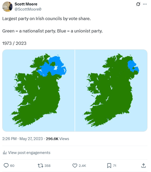
In making this, I referenced maps that were on Wikipedia. But not all council elections were mapped. In fact, the more I edited Wikipedia, the more I realised that many things were difficult to find online, if not non-existent.
Last winter, I thought once again about that 1973/2023 election map I made, and sought to make more election maps, that went more in-depth to District Electoral Area level, and maybe even ward level (with the help of statistics and data science methods).
While recent NI council ward maps were publicly accessible, the 1984 and 1971 ward maps weren’t. Nor were most boundary maps from 1920-1971.
I scoured the internet, but I found very little. I asked the Ordnance Survey of Northern Ireland (OSNI) directly and after a while, I got around 126 high-quality maps of local government boundaries, and they agreed they would publish these on Open Data NI. I put the scans online myself in the meantime.
But these were scanned images - not digital boundaries, which can be used in online zoomable interactive maps. And it became clear this would cost too much for a public body to do.
Meanwhile, I scanned books from libraries. Initially these were reports of boundary commissioners, explaining the decisions about where to draw boundaries.
But I found other books which weren’t online, which could legally be scanned and redistributed. I am thankful to the Linen Hall Library for letting me do so.
I added assorted files to my Internet Archive collection, alongside the scanned maps and books. But I was still itching for the accurate digital historic boundaries.
If you want something done, do it yourself.
QGIS (Quantum Geographical Information Systems) is a free programme used to edit digital map files. These come in formats such as ‘Shapefiles’ or ‘GeoJSON’ files.
Having a Shapefile is like an ‘exact’ map (more or less). You can zoom in as far as you like and it’s still the same, no pixelation.
I gave QGIS a go a while ago and tried to learn it. I progressed slowly, but eventually I made breakthroughs.
I used a few sources. Firstly, some of the 1992 wards were unchanged from 1985, so I copied and pasted those from OSNI’s digital 1992 ward map.
Secondly, OSNI have released digital maps of townland boundaries. Many historic wards are just a load of townlands stacked atop each other in a trenchcoat. It’s like a big jigsaw puzzle. I used my historic OSNI scans (on my Internet Archive account) and compared the shapes of wards to ensure I didn’t miss anything.
I also used the fantastic historic Parliamentary constituency maps from parlconst.org, as these coincided with a few ward boundaries.
Eventually I drew boundaries manually in QGIS, along streets, fences, fields and rail lines, and so on.
The released product can be seen here, as an interactive map, on boundaries.scottmoore.xyz. It includes a map of 1984 council wards and the councils themselves.
I owe thanks to politicians I wrote to, including:
Kate Nicholl MLA (chair of the All-Party Group on Policy and Public Data) for chasing up my questions with the Ministers of Finance and Communities;
her MP colleague Sorcha Eastwood, who tabled a question in Parliament on releasing Command Papers to the public;
my West Tyrone constituency MLAs Tom Buchanan, Daniel McCrossan and Nicola Brogan who also wrote to Ministers/Departments and/or submitted questions;
my constituency MP Órfhlaith Begley, who also chased up my query on Command Papers.
And, of course, a thank you to the people at OSNI for their diligence, guidance and assistance.
I have appreciated the praise in the past couple of days, but I’m not seeking any plaudits or pats on the back. I am pursuing a broader vision.
Wards, DEAs, councils, Parliamentary constituencies, settlements, Census Data Zones, and more geographical units besides that - all have data attached to them.
Census and demographic statistics, election results, deprivation indicators. Candidates standing, politicians elected, how many votes, and for what areas. The names of those politicians (literally, their first and last names). Each word those politicians said in the Assembly or Commons chamber, and at what frequency. How they voted - for, against, abstain or no vote - on different decisions. Public spending. Opinion polls. Even weather patterns, geological patterns, rivers, basins, mountains, closeness to trains/motorways or to hospitals or to prisons or to police stations! The list is genuinely endless.
I want to bring as much of this as possible together, put it into a machine learning model, and see what comes out. I want to analyse social and political change - especially amid ongoing debates on the constitutional future of Ireland.
And the digital maps and boundary data are crucial to be able to do this, because the Census boundaries vary, and wards/constituencies change every 10-15 years. Meaning they can’t usually be compared like-for-like over decades.
I intend to write about this topic for my data science Master’s research project, and the 1984 ward map will be one of a few I want to make, which I will use in that project. But I am going beyond the work required for the Master’s project, by making as many info and docs publicly accessible as I can.
I have done all this voluntarily and will continue to do so regardless, whenever and wherever I can find the time.
Things I want to work on include:
Scanning more Crown copyright items and other legally-scannable items from the Public Records Office in Belfast, Libraries NI branches, the Linen Hall Library, and the Stormont Library (accessible by appointment)
Cleaning, ward-labelling, and improving existing digital maps I have made (namely, the 1984 NI council ward map and the 1984 NI council map
Adding new digital boundary maps from historic map scans and other sources (like the 1971 council ward map, the 1971 council map, the 1973 DEA map, and pre-1973 council boundaries)
Doing similar work for maps and boundaries across the rest of the island of Ireland
Getting better at using QGIS and other GIS tools so I can make maps more quickly, efficiently, and cleanly
If you can assist with any of these, please reach out! I can give you step-by-step instructions of what needs to be done. If you have your own enquiries similar to mine, I am more than happy to steer you in the right direction.
I’ve done all this despite working a full-time job, and still studying for my Master’s. This work, on top of that, is undoubtedly time- and labour-intensive. While I took gaps and breaks in making the 1984 ward map, I first started it a month ago.
I am also paying for this web domain, web hosting, and numerous different subscriptions, all to do with this work. There are scans of certain maps I’d like to obtain at a professional high resolution, but these could prove costly.
This work is beyond what is required for my Master’s research project, as I am uploading docs and maps publicly whenever I can.
In light of this, if you wish to contribute financially, I would welcome any support.
You can:
Subscribe to this Substack from £5 a month, or £45 a year - I will post monthly updates on my work so you can keep informed
Or, send me a tip on Ko-fi from £3
I will work on all this voluntarily regardless, and there is no obligation to sub or tip - but with more money, I can spend more on this work.
Despite limited time, I’ve worked very hard over months and uploaded a wealth of maps, books, documents and info already. My Internet Archive collection, and meticulous boundary maps I’ve produced myself, show this.
With your help, I can take it to the next level, and I’ll keep you updated along the way.